
Are you looking to get away while still practicing safe social distancing? Check out this 4-day itinerary for an epic USA road trip to: Nevada, Arizona & Utah.
What I love most about traveling is the opportunity to unlock doors within me I hadn’t known existed, with each door leading to an endless maze of new doors waiting to be opened. To me, there isn’t a more satisfying and desirable feeling than finding yourself in a strange place, making new friends with unfamiliar faces. I could travel thousands of miles to dozens of countries, however, what feels most like uncharted territory is what is still left to be discovered within me.
– Me =)

When planning a new trip, I’m so quick to want to leave the country (LOL). Often, I feel as though I haven’t made the most of a trip unless I get a new stamp added to my passport. Therefore, I have sadly seen very little of my own country. For better or worse, so much of American culture and history shapes who I am – yet, I barely know her.
SO, for my 31st birthday, I decided to change that. Myself, my cousin and good friend of mine booked three flights and set off to hit the road of the American southwest. Limited by time and money, we somehow managed to squeeze in over 1,000 miles of terrain in less than 5 days.
Buckle up. We’re going an USA road trip!

DAY ONE: Arrival to Las Vegas, The Narrows at Zion National Park & the Colorado River Horseshoe Bend
Depending on where you are traveling from and the mode of transportation, there are several places to begin this USA road trip. However, for this guide, we start in Las Vegas, Nevada. We flew into McCarran International Airport, arriving just before midnight.
Have You Ever Slept Overnight At An Airport?
Now, if you’ve been following my other guides, you’d know that I like to keep costs down as much as possible. Being that we had arrived in the middle of night and planned to begin our road trip before dawn that next morning, we didn’t want to waste money on a hotel room for literally only a few hours. So . . . similarly to other stragglers hanging around the airport, after landing, we decided to make ourselves comfortable in a random terminal near a few slot machines.

Thank goodness we had a tank-full of adrenaline and excitement that next morning because we didn’t sleep well at all – LOL!
Zion National Park

After collecting your rental car for the next few days, I recommend making a pit stop at the local Wal-Mart. Plan on spending many hours in the car, often without many options on the route for food or bathroom breaks. Our first stop on this USA road trip is Zion National Park. The trip from McCarran International Airport takes around 2.5 hours.
Admission Price
Zion National Park is located in the southwestern region of Utah. There is a $15 admission fee per vehicle. However, active duty military and families are granted a free annual pass to any national park.
Park Hours: What Time Should You Arrive?
During peak seasons, traffic congestion is known to be a huge problem at Zion. To increase your chances of getting a parking spot at the Visitor’s Center, I highly recommend that you arrive early – let’s say no later than 9 A.M. When we arrived around 8:30 A.M., there was already a long line of cars waiting at the entrance. You could easily spend several days at Zion, as there are various hikes/attractions to choose from, ranging from half an hour to 4 hours long. Due to time constraints, however, we decided to just hike The Narrows.
The Narrows @ Zion National Park
The car park is next to the Visitor’s Center. From there, you can take the free shuttle to the last bus stop, which will be at The Narrow’s. The Narrows hike is best done during the summer, as water temperatures during winter are frigid. We attempted to hike The Narrows during winter without renting any waterproof gear from the Visitor’s Center – HUGE mistake! I barely lasted 5 minutes before turning back because the pain was so excruciating. LOL! The gear isn’t the most affordable to rent, but I highly recommend that you do.
The Narrows is a 3.6 miles (5.8 km), bottom-up, river hike. You could extend your hike up to 16 miles (26 km), but an additional permit is required. For most of the hike, you will be submerged in water – even up to your neck at certain junctures. Be sure to stop by at the Visitor’s Center for information regarding water temperatures and safety, as the river is a flash flood zone.


Colorado River’s Horseshoe Bend

We departed Zion National Park around 2:00 P.M. giving us a chance to drive the 2 hours necessary to reach the infamous Horseshoe Bend just before sunset. The Horseshoe Bend will be our third border crossing in a single day, as it is located in the small town of Page, Arizona.
A Few Noteworthy Details . . .
There is no admission fee, and there is free parking on-site. It takes around 30 minutes to one hour, depending on your walking pace, to reach the cliff’s edge from the parking lot. The walking trail itself is fairly easy to walk. With a 1,000 foot (300 meter) drop, the view of bend is astonishingly beautiful, especially with the backdrop of the sunset on the horizon. Definitely a must-see stop on your American road trip.

DAY TWO: Antelope Canyon & Monument Valley

Antelope Canyon
We spent the night in a local hotel before heading out 15 minutes from Page towards Antelope Canyon. There are several tours companies available to explore the slot canyons. We opted for an organized, photography-guided tour. Our reasoning for this is because the photography tour allows for more time and for seclusion. We chose a lesser known, local tour company called Antelope Canyon X with Taadidinn Tours.
Antelope Canyon X, as well as the land, belongs to the Navajo Reservation. It costs around $80 USD per person, which is half of the price other companies offer. For around 2.5 hours, we had the entire canyon pretty much to ourselves, without any obstructions of tourists sauntering into our photos.
Our tour guide was kind enough to share the beautiful and tragic history of her people and tribe. Facing expulsion and genocide, our guide described a time where the Navajo people would hide and seek refuge, in the very same canyons we were touring, from European invaders. We felt so honored to be welcomed to explore their lands and honored that she would share their struggles with us.
Monument Valley

Moving right along on our USA road trip! After ending your tour at Antelope Canyon, first, I’d recommend heading back to Page to grab a bit to eat, take a bathroom break, and/or fill up on gas. We’ll have around a 5-hour drive ahead of us until we reach our final destination to Moab, Utah.

Making A Pit-Stop at Monument Valley
Located near the Arizona-Utah border within the territory of the Navajo Reservation, lies Monument Valley. You may recall in the movie Forrest Gump, after he had been running for months and then suddenly decides to end his journey on this barren road with a backdrop of the famous, sand-stone buttes. On your way to Moab, Utah, you’ll drive right through it on U.S. Highway 163. This would be a great opportunity to stop for some Insta-worthy pics.
DAY THREE: Arches National Park
From Monument Valley, the drive to Moab, Utah is just under 5 hours. After getting a good night’s rest in Moab, Day 3 is all about exploring Arches National Park (my fav!). Honestly, I would go back and just spend 4 days here. I love Utah!

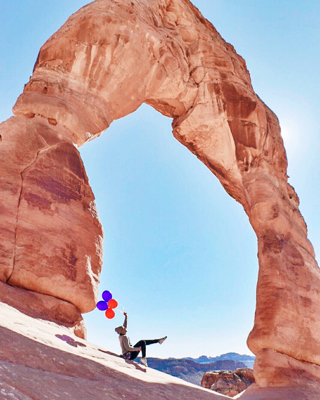
How Stunning Is the Delicate Arch!?
With more than 2,000 natural, sand-stone arches are located in the park, we narrowed down our stops to under a dozen. The park itself is well-maintained, has nicely paved roads and on-site parking. Admission is $25 USD per vehicle. Arches also provides for overnight camping and star gazing. There’s nothing like seeing a billion stars in the night’s sky.
Things To See @ Arches National Park
Below are my recommendations for notable points of interest within the park:
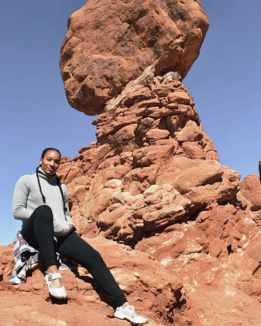
- Balanced Rock – 0.1 mile hike – Duration 3 minutes one-way
- The Windows – 0.3 mile hike – Duration 7 minutes one-way
- Double Arch – 0.3 mile hike – Duration 6 minutes one-way
- Delicate Arch – 1.5 mile hike – Duration 42 minutes one-way
- Sand Dune Arch – 0.1 mile hike – Duration 2 minutes one-way
- Skyline Arch – 0.2 mile hike – Duration 4 minutes one-way
- Landscape Arch – 0.9 mile hike – Duration 22 minutes one-way
- Wall Arch – 1 mile hike – Duration 24 minutes one-way
- Devil’s Garden – 1.9 mile hike – Duration 48 minutes one-way
- Double O Arch – 2 mile hike – Duration 50 minutes one-way


DAY FOUR & Last Stop On Our USA Road Trip: Seven Magic Mountains & Las Vegas

In retrospect, I wish we would’ve had more time to spend in Moab because the number of activities available are limitless. It’s SO beautiful! You guys, it was my favorite stop on this USA road trip. However, with only four days allotted for this trip, it was time to go.
The Scenery On the Drive Back to Las Vegas Is INCREDIBLE!
The journey back to Las Vegas is around 7 hours. We had a long day of driving ahead of us before our flight later in the evening, BUT the drive back is not boring by any means. Utah is is an incredibly beautiful state. The natural landscapes are breathtaking. You’ll be driving through mountain ridges and incredible mountain peaks. At certain elevations, there may even be snow on the side of the road. Also, in certain phases on this road trip back to Las Vegas, the speed limit is 80mph. That’s right! Utah is known to have some of the highest driving speed limits in the country. Be sure to obey them, however, since there are lots of state troopers enforcing speeds.

The Seven Magic Mountains
Once we arrived back in Vegas, we had around 8 hours or so to kill before our flight. We decided to head to our last attraction of the road trip, which is just under 30 minutes outside of Las Vegas: The Seven Magic Mountains. The Seven Magic Mountains are an art installation of seven, neon-hued pillars standing alone in the desert. There is no fee to visit them and there is a gravel parking lot on-site. There is no public transportation that will get you there. The exhibit was constructed in May of 2016 and was only meant to be a two-year installation. Lucky for us, as of June 2019, it seems like it’s still up and running, so be sure to check-it out.
That’s All For Now, Folks!
Our 4-day American, southwestern road trip has concluded. I hope that you found this guide helpful. Feel free to leave comments or tips below on how to improve this guide or things you enjoyed most on your trip! The more collaboration we have with one other, the better we can support our fellow travel tribe.
If you would like to see more content of my travels, feel free to visit my YouTube Channel here, as well as my Instagram here.
You can also find the entire travel vlog series of my road trip here.
Thanks for stopping by, and Happy travels!
